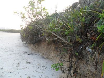


 TODAY IN PICTURES SHOW A QUANTITY OF LAND, WHICH LOSES IN COASTAL CYCLE DUE TO LAST RAID OF TIDE TO THE BEACH Itaguaré worsen the EROSION OF EXPOSING THE ROOTS OF restinga vegetation.
Studies coordinated by geologist Celia Regina de Gouveia Souza shows that Itaguaré beach erosion presents strong evidence - a growing problem on the coast.
The data indicate that in 2001, 22.8% of the beaches in Sao Paulo were 'very high risk' of erosion. In the last survey, done in 2007, this figure rose to 33%. Meanwhile, the beaches at low risk of erosion fell 5% in 2001 to 2.3% in 2007. "In other words, the situation tends to get worse."
For the researcher, the reasons are inadequate occupation of the coast and coastal plains, which, among other factors, removes the original vegetation of "sandbank" and amend the drainage network - in addition to natural features such as the current rise in sea level .
Comparison
A study released by the IBGE showed that between December 2001 and December 2006, the sea level along the Brazilian coast has risen an inch.
In the coast, tide gauge data collected by (an instrument that records the ebb and flow of the tides at a given point on the coast) of the Oceanographic Institute of USP, installed since 1954 in Cananea, show that in recent 55anos sea level rose in the region 30 cm.
As a reference, data from the Intergovernmental Panel for Climate Change (IPCC / UN) indicate that sea level has risen on average 20 cm around the world from 1990 until 2006.
Island Porchat
To Celia Regina, the more the level rises, the greater the cases of erosion. She cites as an example of this clash between the sea and human occupation, the Kinks Beach in San Vicente.
'When they made the connection with the island Porchat in the late 1940s, created a blockage that prevents the sand from the beaches of Itararé comings and Santos reached the Kinks, on those beaches that had its main source of sediment. In the early '50s began to emerge the first signs of heavy erosion, "he says.
Celia explained that the City Council at the time, began to build stone piers to lessen the impact. However, these interventions only worsened the problem.
"These piers serve as a trap, trapping sand on one side and increasing erosion on the opposite side, because blocking the coastal currents that carry sand along the beach. Today, much of this beach is disappearing, a process that tends to intensify, especially with global warming and rising sea levels, "says the researcher.
The shuttle's trip
The coastal plains are the result of a slow and continuous process of rising and falling sea levels, the result of interspersed periods of heating and cooling the planet.
Between 1.5 million and 18,000 years before present, the Earth passed through four glacial periods. Them, global temperatures dropped, the sea receded and the great masses of ice, now confined in the South and North poles, grew up and moved toward the equator.
However, in the interglacial periods, when the temperature rose, the ice melted, the sea retreated again to rise. For about 120,000 years ago and also 5600 years, for example the sea in certain parts of our coast, came to the foot of the Serra do Mar, then to slowly recede.
During these retreats, the sea was leaving rows of beach, which now fill much of our coastal plains and became the paleopraias. At each new rise in sea level, some of these paleopraias are eroded.
It was thus eroding and depositing sediments that our coast has been getting the current features. The beaches as we know them today were taking form there are about 1500 and 2000 years, when the sea was receding to the level near the present.

Nenhum comentário:
Postar um comentário